A little about the area
The West Kootenay area (referred to as Central Kootenay as a political riding) comprises a topography fashioned by water and ice, creating narrow north-south river valleys and lakes. Areas of flatter grassy lands exist but are uncommon, replaced instead by extensive mountain ranges and high-altitude treeless meadows and boulder fields above the tree-line. Deciduous forest is much less likely than mixed coniferous stands, extensive in some places, ranging from elevations of around 400m to alpine zones with peaks to almost 3000m. The interior temperate rainforests vary from limited pockets of dense old growth cedar, hemlock and spruce to open scattered larch and fir stands.
Settlements are relatively small (Nelson is the largest concentration of people at around 11,000) and often well separated. Although birding is popular, such is the expanse of accessible areas that it is unlikely that you will meet anyone else with a Sibley or Cannings (Birdfinding in British Columbia) field guide in their back pocket.
All images in this article are the property of Chris Drysdale/Cloudside Hotel.

Castlegar: Selkirk College Trails
An extensive network of trails weaves its way around and across the floodplains where the Columbia converges dramatically with the Kootenay River. It is often incredibly quiet and under-visited, even in summer, despite the variety of pathways, its scenic rocky backdrop and proximity to the busy town of Castlegar. Access is easy for all abilities. Free parking is found in (at least) three sports: hard left as you pull off onto Rosedale Road from the highway just after the high bridge crossing the Kootenay River; at the end of Welsh Road, which is a great birding spot; and in a large, rough pullout just before you reach Frank Beinder Way at the other end of Rosedale Road. Be aware that there are no washrooms anywhere on the site.
Broadly speaking, there are three parts to the trail network: the open coniferous stands west of the arterial Frank Beinder Way; the broken deciduous pockets and grassy meadows east of the road before the river foreshore; and the current floodplain which includes a seasonally filled oxbow remnant. There are only boot-beaten tracks on the latter, which is often the best place for birding, while good signage helps the walker navigate the other two areas.
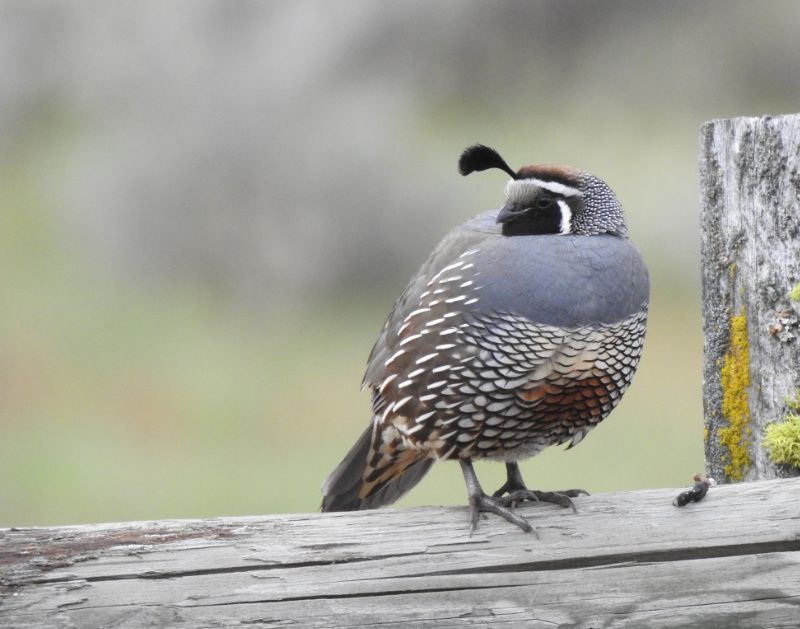
Castlegar: Selkirk College Trails
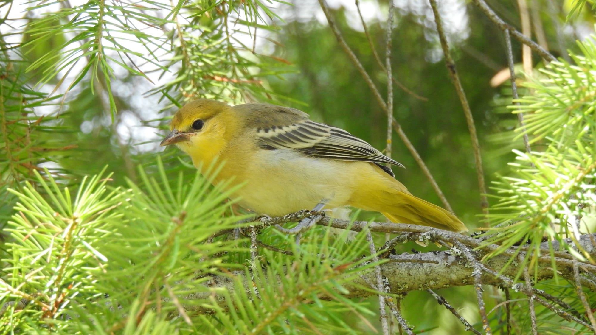
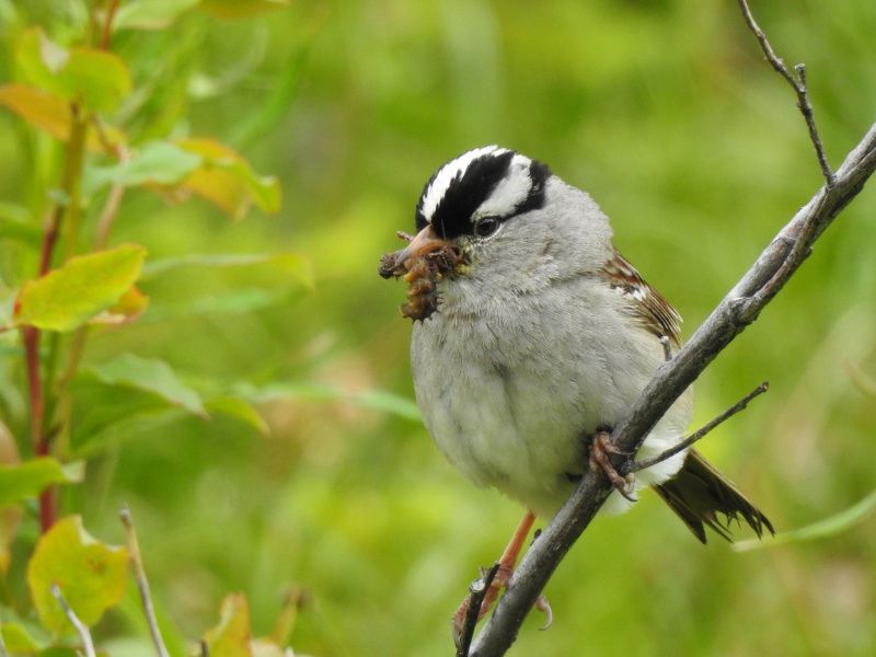
In winter, huge flocks of Barrow’s Goldeneye congregate to rest and feed, interspersed with numerous Common Goldeneye, Bufflehead, Common and Red-breasted Merganser and on occasion the odd Scoter or Harlequin. Pipit, Hooded Lark, Snow Bunting and Lapland Longspur are regulars on passage and American Kestrel, Northern Harrier, Peregrine and the less frequent Short-eared Owl keep an eye on the more open lands. Inland, many expected interior woodland species are often easily seen. Sixteen sparrow species have been reported, albeit with a couple of rarities such as Harris’s and Lark. eBird shows more than twenty duck species along with many other shorebirds and waders, making this spot a real draw in a region full of plunging valleys and steeply wooded slopes. https://ebird.org/hotspot/L1497984
The trails are reached in just under 30 minutes by car from Nelson. There is a public bus service as well, mainly aimed at the college students, and you will find details here: https://www.bctransit.com/west-kootenay/schedules-and-maps/route-overview?route=99. Allow a minimum of an hour and a half if you just want the edited highlights, which would be a 2-3km loop along the oxbow and floodplain, and a full half day if you wish to dive deeper into the forests and chart a course through the western sections.
Nelson Waterfront
If you visit Nelson (which you must!), the waterfront is virtually unavoidable. It runs for just shy of three kilometres from its western extremity to the landmark affectionately known as BOB, the Big Orange Bridge. On the eastern side of the bridge the area is known as Nelson Landing and becomes a quite different, slightly less productive habitat.
The entire area is easily accessed by all abilities. A suggested itinerary would be to park (it’s free) at the end of Lakeside Drive and start your walk just beyond the city airstrip. Dead ahead and to your left is the site of the old Nelson refuse site. There are sometimes good birds here, including the odd wader on return passage in fall, but access is restricted (though rarely enforced), and the habitat, already seriously polluted, is very degraded due to the current land-use practices of the municipality. We would not recommend crossing City property to access the bay to the west of the parking area.
Instead, stroll the pathway by the lake and look for various sparrow, finch, warbler and other small passerines such as Common Redpoll and Northern Shrike in winter and various flycatchers in spring and summer. Willow, alder and tansy scrub create a narrow border between the walkway and the river. The cold season brings large gatherings of scaup (almost all Greater), scattered grebe (all expected except Clark’s), Redhead, Ring-necked Duck, a few teal and wigeon, plus the odd swan (Trumpeter and Tundra) and gulls (California, Herring, though predominantly Ring-billed).
Nelson Waterfront
Your first turn around point comes after about one kilometre when you reach the end of the rough pathway and get into a more built-up area by the marina. There is a public washroom here, and you can get food and drink at the Prestige Hotel. If you carry on, look for Redhead, Bufflehead and Common Merganser (and possibly Common Loon) as well as Barrow’s and Common Goldeneye as you pass by the moored boats and onto the sidewalk by some rail tracks. Don’t worry, this is not the main line but a short track for the restored streetcar which runs for fun in the warmer months. You will hear it coming and the volunteer drivers love a chance to ring the bell.
The section in front of the mall is one to walk at a brisker pace as you won’t miss anything here, but slow down as you reach an obvious inlet known unofficially as Duck Bay. There isn’t usually anything different on the water, but the bushes can hold a few different species such as Red-winged Blackbird and House Sparrow (far more uncommon here than in many urban areas of the world).
You are then into the well-tended grounds of Lakeside Park. This affords a pleasant walk, but even when you pass the football fields and reach the shaded easterly end of the waterfront you probably will see little of real interest unless you are still chasing the common local birds such as Northern Flicker, Steller’s Jay, Black-capped Chickadee or Song Sparrow. There are too many people and it is just too manicured to be truly interesting, although it is one of the prettier spots you will visit to see birds in an urban area.
You will pass a couple of sets of washrooms before you get to the beach, and there is a third set by the children’s play park. There is also a nice little café and it’s a great spot to eat, though you will find the most interesting thing to watch here is the people, not the birddlife.
Nelson Waterfront
At the end of the beach (2.8km from start) you have to go under the ramparts of the Big Orange Bridge to continue. Cross the parking lot and look for a narrow entrance to a pathway right up by the railway line. The path goes through a few trees for a couple of hundred metres until you reach a quiet residential street (Beatty Avenue). A Lewis’s Woodpecker was seen here in 2019 so keep your eyes peeled.
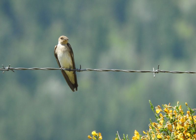
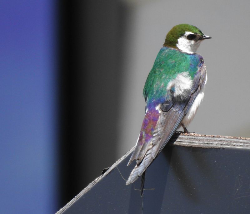
After another hundred metres or so there is an obvious trail which drops sharply back down to the waterside on your left; this is John’s Walk. A pleasant ten minutes will bring you to the end of the buildings and into some dense scrubby weeds. This is the start of Nelson Landing, an area of reclaimed land which was once used by a forestry processing business. A hulking metal jetty dominates your view to the left, look for Cliff Swallows nesting (along with the more common Violet-green, Tree and Barn Swallows) in the early summer. There may be, or have been, some work at this site building a new ferry for the Lake; plans are not entirely clear as this text was written (March 2021).
Nelson Waterfront
You are now out of the houses. This patch of scrub is (in season) always busy with White-crowned, Song and Savannah Sparrow along with many Common Yellowthroat. Common Merganser gathers in double figures in the sheltered waters just offshore. This area is not a particularly birdy hotspot but it is good to be away from the crowds which camp out on the beach and Lakeside park, and the many stroller and dog-walkers you will meet at the beginning sections of the pathway. You can walk for a couple of kilometres before you are obliged to quickly cross the railway track onto the lovely Bealby Point Road. DO NOT carry straight on through the woods as the path ends up on Red Sands Beach which is clothing optional. Feel free to hang out for a while if you wish, but suddenly appearing out of the foliage sporting binoculars and a camera would not be a good way to make friends with the locals.
Bealby Point Road has no sidewalks but is always quiet. It’s worth it just to be out of the town but it isn’t remarkable from a birding perspective. It’s 1.3km from the end of the scrubland track to the end of the road, which is a dead end.
Kokanee Creek Provincial Park
It will take you about twenty minutes to drive the scenic road from Nelson to the gates of the park. As a prime beach and camping location it can get very busy in July, August and September but is still worth a trip as it’s surprisingly easy to find some space and quiet.
It is best to park in the open day-visitor spaces of Friends Campground. This is to the left once you have pulled off the highway. You don’t need to go by the registration station on the right unless you are going to camp. There are obvious (and usually very clean) washroom facilities here. In winter, you will have the place largely to yourself, but as this is the parking lot for the long sandy beach with a gorgeous view up the lake, it will be busy in summer. Even then, if you trek off to the right (virtually due south), you will find a footpath which begins just inshore of the water to the left of the children’s play park, and you will quickly be into the woods and only meeting people occasionally.
Once on this path you have, from the time to time, the choice of heading out to the water or back inshore to the main Sandspit campground. The environments are totally different: the campsites are set under towering, shady conifers while the foreshore is damp, grassy and open, with small pockets of low willow and tangled bushes.
Kokanee Creek Provincial Park
You won’t see too much spectacular birdlife in the taller trees inland although they can get very busy with the regulars, especially around the perimeter road. The area between the campsites and the beach, can, however, prove much more interesting with patience, and has held Clay-colored, LeConte’s, Brewer’s and Vesper Sparrow, all seen in the last couple of years, as well as several flycatcher species, Northern Shrike, Yellow-breasted Chat and a number of raptor species (Prairie Falcon was seen in September 2018). Black-billed Magpie and Blue Jay are considered unusual in this part of the world but put in the odd appearance, and it’s always worth checking the gulls and waterfowl on the shore edges or in the main lake channel.
You will reach a point where Kokanee Creek empties into the lake and a path leads you back into the inshore woods. Dipper is always around somewhere! The star attraction here, at least for three weeks or so in late September, is the endemic Kokanee Salmon. A spawning channel with viewing platforms has been created through the forest. It’s very nicely done, with information panels and great close-up observation opportunities if you are here in the fall. Follow the boardwalks and pathways and you will find yourself at a T junction after 5 minutes: right goes to the visitor centre (always helpful rangers!), and left takes you into more camping spots and a path to the beach on the downriver side of Kokanee Creek.
Kokanee Creek Provincial Park
In the interests of completion, it’s a bit of fun to explore this area, called the Group Campground, but it isn’t the birdiest part of the park. After crossing the bridge there is a path on the left running down to a beach which is often empty and always quieter than the main beach.
If you had taken the right fork on the spawning channel boardwalk you would arrive at the visitor centre and then have two choices: right, which takes you behind the Centre onto the Thicket trail, and left into the campsite. The Thicket trail ultimately takes you back to the aforementioned grassy area and shoreline, and, true to its name, has some densely tangled undergrowth which is good for warblers, American Redstart, flycatchers, and vireos et al in the spring and summer.
Taking the left will ultimately return you to your vehicle if you have followed this itinerary to the letter. An interesting side trip is marked by a sign saying Darkwoods Trail about 20m on the left of the road which leads away from the visitor centre ‘loop’ road. The path, faint at times, will take you or under the highway to a number of well marked paths through the woods on the northern side of the highway. A good place to start is the Canyon Trail which hugs the creek bank and will lead you to the canyon lookout. You can look for Western Tanager, sapsuckers, woodpeckers, Brown Creeper, Varied Thrush, Junco and various other species common in lower elevation coniferous forests.
Kokanee Glacier Provincial Park
From Nelson drive past the entrance to Kokanee Creek Provincial Park and look for a road switching back sharply on the uphill side about 400m further along. This maintained forestry service road (also signed to the Kokanee Zipline) is by far the easiest local access to the stunning higher ground. It is unpaved but passable from early to July until October. Unless there has been a washout (see para below for road updates) it will be suitable for all vehicle types, two-wheeled drive with summer tires included.
It delivers you right to the trailhead (1536m, outhouse, picnic tables) with little drama in as little as forty minutes. You could circuit Gibson Lake here in less than one hour, but it’s only an hour and a half of steady climbing before you reach Kokanee Lake (not to be confused with the rather bigger Kootenay Lake down below). Now you are officially in the sub-alpine with a few changes in bird-life (Townsend’s Warbler, Clark’s Nutcracker, Olive-sided Flycatcher, Fox Sparrow and possibly Golden Eagle by way of a few examples). The well-trodden pathway continues for many kilometers into sublimely beautiful mountain scenery.
Before you go always check the road status on the excellent and well-used West Kootenay Hiking Access page at https://www.facebook.com/groups/1389190787797385/).
Creston Valley and Wetlands
Just over an hour’s drive outside of the local area, but a very worthwhile day trip from Nelson. At the heart of this patch is the Creston Valley Wildlife Management Area (https://crestonwildlife.ca/) but driving and walking around the floodplains, fields and marshy areas outside of its boundaries is almost always rewarding.
Many species which are not common or rarely seen in the rest of the West Kootenay are regulars here. American White Pelican, Sandhill Crane, Black Tern, Yellow-headed Blackbird, American Bittern and Ring-necked Pheasant are occasional, sometimes reliable visitors, and a cast of various waterbirds, notably waders and shorebirds, are regularly seen on passage. The eBird link to get you started is https://ebird.org/hotspots?hs=L299701&yr=all&m=. Be aware of seasonal closures on the dyke road access to Duck Lake from the southern side.
Nelway/Waneta Road and the Pend d’Oreille Valley, Trail
Although it cannot claim much in the way of different avifauna, the area immediately north of the US border, south of the city of Trail, offers a quite different birding experience. Explore the quiet lanes through pasture land and meadows dotted with deciduous trees and brush as well as the omnipresent conifers. Another big difference between this area and most other local lowland birding sites is that this is not dominated by a water feature (lake, river or shoreline).
It is a good spot for Say’s Phoebe and Western Bluebird which arrive in March, and it’s a holdout for California Quail and Wild Turkey which appreciate the agricultural land use. This is a sprawling area, rather than an in-and-out site, so it’s best to commit some time to driving around and occasionally striking out on a path or laneway.
A good plan is to drive to Trail Airport and keep going south on Highway 22A (Waneta Highway). Take the turning on your left onto Waneta Nelway Road just before the road crosses the Pend d’Oreille River. After approx. 2.5km you will reach an open crossroad; this is a good place to pull off and park. On the other side, the road stretches for several kilometres. Make sure you have water, sunscreen and a head covering in the summer as it is very exposed. https://ebird.org/hotspot/L939130.

We are here to help!
We hope that this brief introduction will be helpful if you are planning a birding trip based in Nelson, or just a day out in the West Kootenay. Please do not hesitate to contact us in person at the hotel if you would like more information on birds or birding in this serene part of the world.